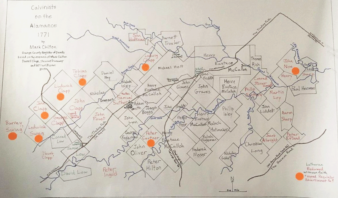
"Calvinists on the Alamance 1771"
by Mark Chilton
Orange County Register of Deeds
Circa 2017, Mark Chilton, Darrell Clapp, Stewart Dunaway and William Moran conducted research to locate 1771* land deeds. In 2017, Mark Chilton published a map based on that research that shows the location of the deeded properties. The map is titled, "Calvinists on the Alamance 1771". Many of the deed owners are buried at Stoners Cemetery. A legend at the bottom right of Chilton's map shows the name of each property owner is color coded to denote whether he 1) was Lutheran, 2) was Reformed, 3) was of unknown faith, 4) signed Regulator Advertisement No. 9.**
In December 2024, John F. Sharp, a descendant of many people buried at Stoners Cemetery and an active member of the Stoner's Preservation Committee, attended a lecture at Alamance Battlefield, learned about this map, and provided a copy to the webmaster. John noted that Conrad Stoner's property, bordered by the Great Alamance, has in the lower corner a little symbol with the cross on top of it. This was the location of Stoners Church.
*The significance of the year 1771 is that it was in March 1771 that the governor's council advised Governor Tryon to call out the militia and march against the rebel farmers, who called themselves "Regulators." The regulators had been demonstrating lawlessness, refused to pay fees, and disrupted court proceedings. On May 16, 1771 the Battle of Alamance (aka "the War of Regulation") began. The rebellion of the Regulators lost to the much better organized king's militia. But this battle demonstrated how dissatisfied the population was during the days before the American War for Independence, which began just four years later, April 19, 1775.
**The 1768 Regulators' Advertisement No. 9 was a petition from the people of Orange County concerning their having to pay larger fees, including those for recording deeds, than people in adjacent counties. The petition was written to the Royal Governor of North Carolina (William Tryon). To read more about the Regulator Ad, click on this link.
If you are not a member of the Stoner's Preservation Committee, but are interested in joining to help preserve Stoner's cemetery, please contact the webmaster or James Andrews (<james.andrews@triad.rr.com>).
Contact person for this website is Susan Snyder: susanleachsnyder@gmail.com

